Organiser
NXSN
In the 15th century, Robberg was discovered by the Portuguese and first named 'Cabo talhado' (meaning Sharp Cape). Around the 17th century, it was renamed to Robberg (seal mountain) by the Dutch due to the large population of seals in the region.
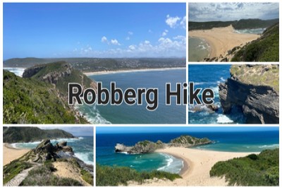
The Robberg Hiking Trail is probably one of the most popular and well known trails in the area and also one of the most scenic. The route is a circular trail along the Robberg peninsula with two shorter variations available ranging from easy to moderate. In the Robberg Nature Reserve live about 6000 Cape fur seals.
Some highlight features of a visit here include spotting the rare blue duiker, the Western Cape’s smallest antelope; walking alongside one of the seven climbing-falling dunes on the Cape coastline; and viewing the highest navigational light on the South African coastline, at the Cape Seal Lighthouse (146m above sea level). The reserve also extends 1.8km offshore, providing protection to a range of vulnerable fish species. Visitors can expect inspiring landscapes, exciting dolphin and whale sightings in season, and to be accompanied on their walks or hikes by a variety of bird species and the occasional seal. An overnight hut is available for those who want to spend more time on this beautiful reserve.
Difficulty is rated 4/10 with uneven terrain and you have to be able to cover the distance and moderate elevation.
🦯🚶🏻♀️🌰🍁🍂 List of compulsary items required for all our hikes:
🌰 Suitable lightweight hydration-/backpack/hip pouch
🌰 Hydration/bottled water
🌰 Sunscreen
🌰 Hat/head gear
🌰 Suitable non-slip shoes (Off road shoes. Normal sneakers/road running shoes are NOT suitable)
🌰 Snacks
🌰 Lightweight windproof jacket
🌰 Fleece/midlayer depending the weather
🌰 Your own emergency items, such as bandage, small petroleum jelly, blister plasters, etc
✨ Optional items:
Fingerless gloves, hiking poles, beanie, buffs, sunglasses.
♡ We'll meet at the Robberg parking area around 7h15.
Maps link:
https://maps.app.goo.gl/sJ397Kpt9Kb5Md5t8
♡ Hike starts around 7h30 when the gate opens.
🎫 Tickets for these hikes are all inclusive, excluding all refreshments. Kindly join the w/a group where arrangements towards lifts/transport to the venue and other communication are done:-
https://chat.whatsapp.com/K5bE7CKzhrrIFv97rUQneH
For any furter information, contact Mariàn on 0727134498.(Also for all emergencies).
More information: www.facebook.com/share/Qs8CAfjwDejyD1Mc/?mibextid=9VsGKo
Images of the event
NXSN
Event location
Robberg Parking area, Plettenberg Bay
| Route information | Take the N2 highway towards Plettenberg Bay. On approaching, take the Piesang Valley turn-off. Follow for 3km until you get to Robberg Road. Continue for 4kms towards the Plettenberg Airport. Turn left at the "Robberg" sign and continue until you reach the entrance gate. |
| Coordinates | -34.1004767, 23.3774233 |
| Address | S34 06.037 E23 22.652, South Africa |
| City | Plettenberg Bay |
| Province | Western Cape |
Registration Number: 2015/141112/07

