
Organiser
NXSN
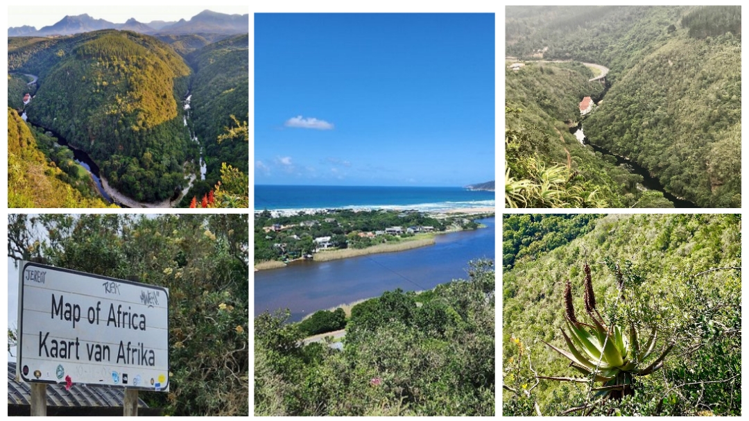
The Map of Africa is a spectacular scene of mountains and forests. The Wilderness area is known for it’s vast number of rivers, lagoons and natural lakes, and here you get a clear view of the Kaaimans River Valley. It is amazing how the course of the Kaaimans River has the shape of the African continent. What a beautiful sight!
High up in the hills of Wilderness, along the famed Garden Route, lies the Map of Africa. A spectacular viewpoint offering a unique sight - quite literally a Map of Africa. Over the years, as the Kaaimans River has flown through the lush landscape it has created a distinct shape of the outline of Africa, and from a certain viewpoint, you can clearly see this mesmerising wonder. Amidst the trees and thick greenery, this tranquil and spectacular stop is the perfect Insta-worthy moment and is sure to bring you real close to Mother Earth. You'll also be able to admire the sweeping views over Wilderness and the paragliders flying overhead as the launch site is nearby. A beauty to behold.
The map of Africa Hike is a 10km scenic circuit route with 230m elevation, starting at the SPAR. After winding past a few local shops and Restaurants, heads up with White's Road along the Touws River. Beautiful views of the ocean awaits before the road takes us in a huge anti clockwise circle towards Remskoen Road, which leads to the Map lookout point. From there we return to the starting point for an optional tea time/lunch at one of the Restaurants.
Difficulty is rated 3/10 looking at elevation and you have to be able to cover the said distance.
???♀️??? List of compulsary items required for all our hikes:
? Suitable lightweight hydration-/backpack/hip pouch
? Hydration/bottled water
? Sunscreen
? Hat/head gear
? Suitable non-slip shoes (Off road shoes. Normal sneakers/road running shoes are NOT suitable)
? Snacks
? Lightweight windproof jacket
? Fleece/midlayer depending the weather
? Your own emergency items, such as bandage, small petroleum jelly, blister plasters, etc
✨ Optional items:
Fingerless gloves, hiking poles, beanie, buffs, sunglasses.
♡ We'll meet at the SPAR, Wilderness where we can safely park our vehicles, at around 6h30 - 6h45.
Maps link:
https://maps.app.goo.gl/99EwBGVyq6v9KxVk9
♡ Hike starts around 7h00 at the SPAR.
? Tickets for these hikes are all inclusive, excluding all refreshments. Kindly join the w/a group where arrangements towards lifts/transport to the venue and other communication are done:-
https://chat.whatsapp.com/K5bE7CKzhrrIFv97rUQneH
For any furter information, contact Mariàn on 0727134498.(Also for all emergencies).
More information: www.facebook.com/share/McHdH8HTNrPoezbS/?mibextid=9VsGKo
Event has been Closed
Images of the event
NXSN
Classes and pricing
Available classes for the event
| Class | Distance | Start Time | Price (pp) |
|---|---|---|---|
| Map of Africa 10km Hike | 10 km | 07:00 | R 80.00 |
Event has been Closed
Event location
SPAR Wilderness, George
| Route information | On the N2 from George towards Wilderness, turn left onto George Rd. After 120 meters turn left onto Leila's Ln. Proceed for 80 meters and turn left again. After 60 meters, turn right. |
| Coordinates | -33.9933763, 22.5747186 |
| Address | Beacon Rd, Wilderness, 6560, South Africa |
| City | George |
| Province | Western Cape |
Event has been Closed